Imagine yourself as an early human. Your tribe lives together and spends days hunting, foraging, and making shelter. There’s a lot of wandering, but what if there was a better way? Could you come back to the good spots again and get there quickly? It’d be even better if another person could understand those directions.
Map-making is one of the first ways humans have made sense of the world. It’s an essential art, as navigation could mean the difference between life and death. Early humans had to visualize the vast Earth, oceans, and continents without tools like satellites, ships, and rulers. So how did they make do?
What is a map?
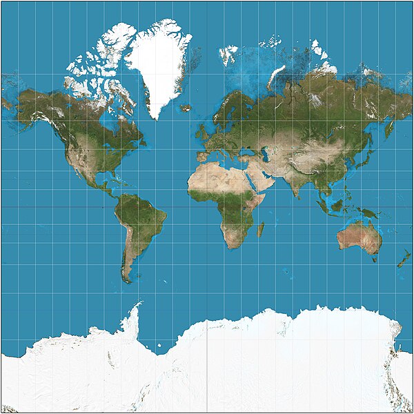
If you imagine a map, it looks like the Mercator Map or even a Google Maps image of your neighborhood. These might be the most popular maps, but they’re far from the only maps humans have made. Maps can be symbolic representations of places that bear minimal resemblance to the real world. Religious leaders have made maps of what they think mythological places look like. In the 21st Century, scientists are mapping the human genome and space. To take something vast and unknowable and make it tangible is deeply ingrained within human nature.
The Mercator Map, used widely even now. Credit Wikimedia/Strebe
The most common maps used for navigation usually represent a geographical area or region. Maps must mean the same thing to all readers, so there are generally common elements. A scale indicates the ratio between the distance traveled on the map and the distance traveled on land. Maps also represent orientation with a North arrow. Each map is unique and made using a specific method.
How have humans made maps?
The oldest tool humans have used to make maps is their eyes! Simple and detailed observations have aided humans in finding their way. Cave paintings have been found in Europe with what anthropologists suspect are star maps.
“Early cave art shows that people had advanced knowledge of the night sky within the last Ice Age. Intellectually, they were hardly any different to us today.”, said Martin Sweatman of the University of Edinburgh in an interview with Forbes magazine.
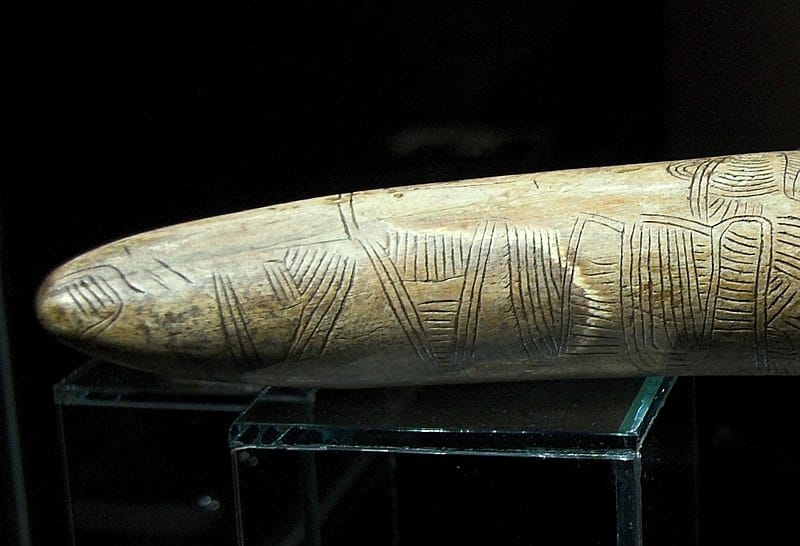
Engravings on this mammoth tusk might represent a map. Credit Wikimedia/Zde
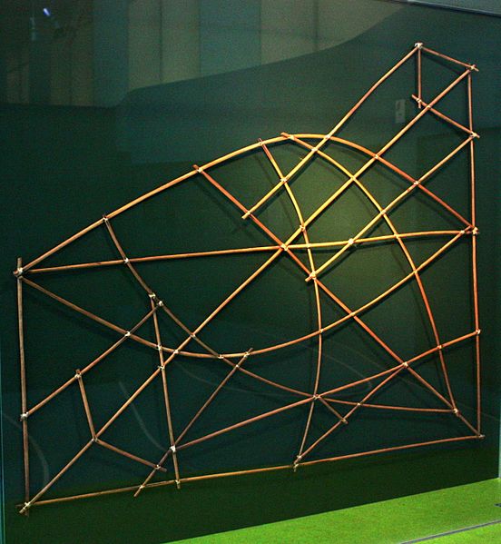
Maps also reflect the needs of human society. We make maps of things that are important to us. Marshallers in Polynesia used stick frames tied together with coconut fiber. These frames helped sailors of outrigger canoes navigate treacherous islands with sharp corals. “The sticks represent ocean currents, wind patterns, and wave swells well known to Marshallese navigators. The cowrie shells represent island groups, not individual islands. Taken together, the bamboo sticks and cowrie shells constitute an abstract navigational chart”, stated archaeologist Stephen Nash for Sapiens Magazine.
This stick chart was a frame sailors would use to navigate. Credit Wikimedia/Sterilgutassistentin
As humans made bigger maps, they also ran into more significant problems. One huge problem was the shape of the Earth. There were dozens of different theories. Some thought the Earth was like a flat plate, and you could sail right off the edge! Others thought it was a long cylinder, with land on the top and bottom and Oceans in between. When Aristotle came along, people mostly agreed the Earth was spherical.
Eratosthenes, another philosopher, used Aristotle’s theory to calculate the circumference of the Earth. He used his eyes, the sun, and geometry to figure this out! Although Erastosthenes’ map of the world was wildly inaccurate, his description of a spherical Earth helped Arab and Persian cartographers.
Arab and Persian cartographers had to contend with an entirely new problem! The Earth being round was great news for artists but bad news for cartographers.
Imagine you’re peeling a nice, round tangerine. It’s a perfect peel, entirely intact. Now try flattening that peel into two dimensions. Some parts will fold and distort. A projection is a way to translate a spherical Earth into two dimensions. It’s a very complicated mathematical formula. A place on sphere Earth goes into the formula, which tells you where the same place would be on 2D Earth.
Muslim scholars of Arab and Persia were at the trading hub of the world. They used knowledge from merchant ships to further their understanding of the world. Suhrab lived in the late 10th Century and created the first rectangular projection.
As humans traveled the world and shared information, they made better and better world maps. The “Age of Discovery,” from the late 15th Century to the early 17th Century, brought the first complete world maps with all the continents.
A map of the world created in 1794 with all the continents outlined. Credit Wikimedia/Thomas Kitchin
If you didn’t enjoy Trigonometry in school very much, you probably wouldn’t have enjoyed being an 18th-century cartographer. After humans understood the general shape of the world, they wanted to make more exact maps. Measuring the distances across vast continents was challenging, but trigonometry and triangulation were excellent tools.
General William Roy was a Scottish military engineer with a dream and an excellent understanding of triangles. Roy made Hounslow Heath in London his base camp, with the first triangle. It was very level, and they could accurately measure the area. They measured a “baseline” here and used it as a standard measurement for other triangles. They then divided Britain into a network of triangles, with only one rule: one side of the triangle had to be the same length as the baseline. Over many years, Roy set up surveying stations across the country and measured the angles between them. By combining the angles and baseline, they calculated the other sides of the triangle. This tradition continued with the Great Trigonometrical Survey of India and the Anglo-French Survey.
Britain divided into Roy's "Triangles". Credit Wikimedia/Peter Mercator
Thankfully, mapping in the 21st Century is a lot easier. Satellites and images of the Earth from space have allowed scientists to understand more about the world and its changes. AI algorithms can be trained to recognize satellite images and make maps. It can also fuse different data sets to allow new understandings. The future of mapping might look very different from the past, but mapping remains valuable to human existence.
FAQ:
Is it possible to make a perfect map?
Every projection has an error. Map makers choose which attribute matters: shape, distance, or area, and choose a projection with the most negligible error for the most crucial attribute.
How did advances in cartography lead to European exploration?
Travel and improved cartography went hand in hand. As Europeans traveled more of the world, they were able to make more accurate maps. They also borrowed technologies that enhanced maps. This, in turn, enabled further travel.
What role did women play in early map-making?
Ptolemais of Cyrene and Hypatia of Alexandra contributed to Ancient Greek maps, though history often forgets their contributions.
Copyright @smorescience. All rights reserved. Do not copy, cite, publish, or distribute this content without permission.
Join 20,000+ parents and educators
To get the FREE science newsletter in your inbox!
SUBSCRIBE TO OUR NEWSLETTER
.......... ..........
Subscribe to our mailing list to get updates to your email inbox.